Heavy rain and strong winds are forecast to hit the Burnham-On-Sea area today (Saturday (October 21st) when Storm Brian sweeps in from the Atlantic.
An intense low pressure system is forecast to bring strong winds into the area, these steadily transferring east through the day.
A yellow warning has been issued by the Met Office which covers the whole south west, including Burnham-On-Sea, from 4am to 11.59pm.
The Environment Agency has issued a flood warning along parts of the Bristol Channel coastline, including Brean and Berrow.
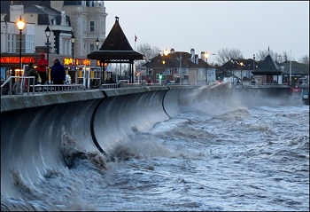 The Met Office says coastal areas may be affected by large waves, with spray possibly overtopping sea walls.
Chief Forecaster Dan Suri said: “Storm Brian is expected to bring strong winds to southern and western areas early on Saturday morning. The first and most significant land-based impacts will be in the southwest of Ireland.”
“As we go through Saturday morning and early afternoon the strong southwesterly winds affecting the South West will transfer east and slowly change direction as they will become westerly towards the end of the warning period.”
“Gusts exceeding 50 mph are expected widely within the warning area, with gusts of around 70 mph along exposed coastal areas. These are expected to coincide with high tides, leading to locally dangerous conditions in coastal parts.”
Coastguards have warned residents not to put their safety at risk by venturing too close to the sea during the stormy conditons.