The coastline around Burnham-On-Sea could significantly change when more than three-quarters of the Severn Estuary’s mudflats disappear over the next century due to sea levels rise caused by climate change, a new report has warned.
The next 60 years could see water levels rise by 30cm-40cm (12-16in), claim researchers at Cardiff University and Environment Agency Wales.
 The ‘State of the Severn Estuary Report’ warns that the impact of climate change could cause 77% of the zone – the area that is above water at low tide and underwater at high tide – to disappear over the next 100 years.
The rapid loss of intertidal areas could have knock-on implications for wildlife that feed on the mudflats and sandflats of the intertidal zone, such as wading birds and waterfowl, with the report warning that intertidal mudflats were of “major conservation importance.”
It is coupled with a warning of repeated flooding in areas along the estuary in the future if no action is taken, and current sea defences are not maintained.
The report – produced by the Severn Estuary Partnership and Cardiff University in collaboration with the Environment Agency – also predicts that 38% of vital saltmarshes could be lost in the next century as they become “squeezed” against flood defences.
The report aims to look at the use and resources of the area “from wildlife to wave formations, energy generation and climate change”.
The report warned that the risk from climate change and flooding in the Estuary had the potential to be “substantial”, due to the number of homes, businesses and crucial infrastructure existing on or near the shoreline.
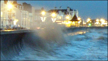 It said: “With sea levels predicted to rise, the risk of flooding and damage to lives and property could increase without significant investment in the Estuary’s coastal defence infrastructure.”
“A recent study using tide gauge data from the Bristol Channel and Severn Estuary found that there had been a rise in mean sea level over a 15-year period from 1993-2000 and that these trends were likely to continue.”
“The Severn Estuary Flood Risk Management Strategy – the Environment Agency’s plan to manage tidal flood risk in the Severn Estuary – predicts that if no action is taken and current sea defences are not maintained, then much of the low lying land around the Estuary will flood several times a year.”
Severn Estuary Partnership officer Paul Parker said: “We believe this report, the first to address such a broad range of estuary-wide features, will inform and raise the interest of all those around the Severn, from residents to industry professionals alike.”
“The SEP aims to aid in the sustainable management of the Severn Estuary through a partnership approach and we believe the further development of robust indicators – in conjunction with annual updates of this report – will help to achieve a sustainable future for this unique Estuary.”