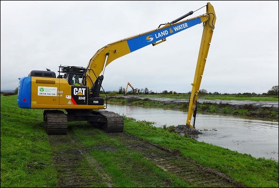
Work has begun on dredging the Cripps River, which connects the River Brue with the Huntspill, just down to the south-east of the M5 near Highbridge and up to the north-east of Bridgwater.
The work is part of a Somerset Rivers Authority plan to improve flood defences across the area.
Desilting of the full 1.6miles of the Cripps is being done by the Environment Agency on behalf of Somerset Rivers Authority, with long-reach excavators being used on both banks by a team of four.
The Cripps is used by the Environment Agency as a channel for moving potentially huge amounts of water from the Brue down to the Huntspill or from the Huntspill up to the Brue.
Operations are controlled via sluices and Gold Corner pumping station, which dominates the junction of the Cripps, South Drain and the Huntspill.
Gold Corner and the Huntspill were built in the early 1940s. Their primary purpose was to supply the 4.5 millions of gallons of water needed daily to help produce explosives at Royal Ordnance Factory Bridgwater between Puriton and Woolavington. However, for nearly 75 years, the combined system has also helped to prevent flooding in the Brue Valley and to maintain water levels suitable for farming and environmental benefits. Nearby are five valuable wildlife Sites of Special Scientific Interest together with the Huntspill River National Nature Reserve.
John Osman, chair of Somerset Rivers Authority, told Burnham-On-Sea.com: “Working with our partners in the Internal Drainage Boards and the Environment Agency, the Cripps was identified as needing work, so I’m very pleased to see it getting underway. It’s a good example of how Somerset Rivers Authority is providing communities across Somerset with higher standards of flood protection than national funding normally allows. Every month, we’re doing more work to improve our defences.”
The de-silting of the Cripps is part of a long series of dredging activities that includes last year’s 8km dredging of the Parrett and Tone, this Autumn’s 2.2km maintenance dredging of the Parrett, new dredging in the New Year of 750 metres of the Parrett near Northmoor, desilting 4km of Hixham Rhyne near Cheddar and 41km of main drain across the Levels and Moors.
While dredging the Cripps, the Environment Agency is also going to investigate whether Cripps Sluice is still needed in its present form or whether it has become an impediment to flow. Historically, Cripps Sluice was used to hold water back for the benefit of the big Wiltshire United Co-operative Society creamery at Bason Bridge – but that closed more than a quarter of a century ago.
Pictured: The Environment Agency has begun dredging the Cripps River, on behalf of Somerset Rivers Authority. In the foreground, a hired 18-metre long-reach excavator; beyond, a 15-metre long-reach excavator


