Experience nature at Steart Marshes
Visiting Steart Marshes

Birds and wildlife on Steart marshes near Burnham-On-Sea
Steart Marshes
The Steart Marshes are a wild, wetland landscape for the future that helps people and wildlife adapt to climate change.
Rising sea levels are putting the squeeze on our coast, so WWT and the Environment Agency have created Steart Marshes, one of the UK’s largest wetland reserves.
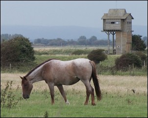
Hundreds of hectares of saltmarsh and freshwater wetlands buffer homes and businesses from rising sea levels, and provide habitat for a rich mix of wetland wildlife including otters, egrets, owls waders and wildfowl.
Steart Marshes is the first of WWT’s Working Wetlands places that demonstrate how wetlands are productive and useful. As well as being a natural buffer, providing protection to the newly created flood banks, the saltmarsh is farmed for specialist saltmarsh lamb and beef, its creeks are a nursery for the fry of important fish stocks, and it is absorbing tonnes of climate-polluting carbon as it matures.
Address: WWT Steart Marshes, Stert Drove, Bridgwater, Somerset, TA5 2PU
Grid reference: ST 25208 44210
Information leaflet: download the map and information leaflet here (or pick one up from the main WWT car park)
Admission is free
Open: all year round: car parks and paths for walkers, mobility scooters, wheelchair users, pushchairs, cyclists and horse riders, subject to a few local restrictions
Parking: The main car park is open all the time, but there is a 2.1m height restriction barrier daily after 4.30pm and before 9am and on Christmas Day. Steart Gate car park has a 2.1m height restriction at all times.
Hides and toilets: Open 9am â 4.30pm every day except Christmas Day, with a few seasonal extensions to these times. They are accessible for wheelchair users. The screened viewing points are open all year round.
Dogs: Welcome on most paths but must be kept under close control to prevent disturbance to wildlife. Make sure you clean up any poo and please take it away with you, there are no dog poo litter bins on site!
Paths: It takes about an hour to walk from the main car park to the breach point. Follow way-marking to new fine-surfaced paths allowing access on foot, some by wheelchair and most by bike. There is also a new circular bridleway. It now forms part of the England Coast Path from Brean Down to Minehead.
Tide times: The rising tide along the Severn Estuary rapidly covers great distances. Watch this amazing natural process from safe vantage points across the site. The tide washes over the developing areas of saltmarsh an average of 120 times a year, tide levels highlighted in yellow in this table will help you plan your visit.
Please note, tides may appear smaller than expected within the Severn. The figures in the table are Above Ordance Datum (AOD) figures rather than Chart Datum (CD) which is a difference of 5.90m.
Refreshments: Fancy a cuppa? There is no cafe on site, but itâs an ideal picnic spot so feel free to bring your own refreshments. To purchase provisions nearby, there are shops in the larger local villages and towns. There are no litter bins on site so please take your rubbish home.
Visiting Steart village’s bird hide
 Steart village is part of the Bridgwater Bay National Nature Reserve (NNR) and comprises 2,564ha located on the north Somerset coast on the south side of the Severn Estuary.
The reserve is part of a larger Site of Special Scientific Interest (SSSI). It is a Special Protection Area (SPA) and is a Ramsar site, and part of the NNR is a possible Special Area of Conservation (pSAC).
A car park is provided within Steart village and a coastal path leads to a number of hides situated at the mouth of the River Parrett.
A tower (pictured here) provides excellent views all round, and an information panel caters for visitors who come either to birdwatch or walk the Parrett Trail following the river from mouth to source.
Significant habitats and species
 The reserve consists largely of tidal mudflats and saltmarsh, sandflats and shingle ridges, some of which are vegetated.
Internationally and nationally important numbers of wintering and passage waders and waterfowl occur, and shelduck also moult within the Bay. Wigeon graze on the saltmarsh. There are ecological links to the adjacent Somerset Levels which provide additional roost and food sites.
Extensive areas of cord grass have spread from plantings in the early 1900s. Sea aster and common reed dominate the upper marsh, while more palatable grasses with sea couch grass are found on the grazed areas.
Management
Wildfowling is permitted within three areas while the main body is a sanctuary. The saltmarsh is grazed by sheep to maintain a palatable sward for wigeon grazing. Coastal processes constantly change the area and a Shoreline Management Plan is being produced to assess the need for future input. The Environment Agency continues to repair storm damaged shingle ridges which protect inland property.
 Location and access
Bridgwater Bay is situated on the North Somerset coast, near the A39 near Bridgwater. The nearest village to the site is Steart. There is an English Nature car park behind the site manager’s house in Steart, although there is non-designated parking areas adjacent to the coastline. There is disabled access to the coastline by public roads. Disabled access to the hides is not suitable, although special arrangements can be made.
Facilities
There are 5 bird hides, and a tower observatory at the site.
There is a path from the car park to the reserve through the woods, which is approximately a mile in length.
There is an interpretative panel in the car park, and also a leaflet dispenser.
Landing on Stert Island itself by boat or visiting it at any time of the year without a permit is not allowed and it is dangerous to attempt to reach the island due to swift-flowing tides and deep mud.

Ducks are among the wildlife on Steart marshes near Burnham-On-Sea