Burnham-On-Sea Carnival road closures and diversions in force
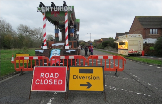
Several roads in Burnham-On-Sea are closed for the town’s carnival, with diversions now in operation.
Motorists are being asked to allow extra time when travelling along the diversion routes, with roads expected to be extra busy.
The road closures that are in place in Burnham-On-Sea this weekend are as follows:
![]() The carnival floats are parked in Queens Drive (from the Tesco roundabout to Stodden’s Lane) and on Frank Foley Parkway (from its junction with Ben Travers Way (North) in a south easterly direction to its junction with Ben Travers Way (South)). Closures began at 9pm on Saturday (4th November) and run through until 1am on Tuesday November 7th.
The carnival floats are parked in Queens Drive (from the Tesco roundabout to Stodden’s Lane) and on Frank Foley Parkway (from its junction with Ben Travers Way (North) in a south easterly direction to its junction with Ben Travers Way (South)). Closures began at 9pm on Saturday (4th November) and run through until 1am on Tuesday November 7th.
![]() The South Esplanade and Pier Street will be closed this evening (Sunday) during the seafront fireworks, which start at 6.30pm – see our Burnham-On-Sea fireworks preview. The closures run from 5pm until 7.45pm, but the organisers hope to open roads up as soon as possible after the event when it is safe to do so.
The South Esplanade and Pier Street will be closed this evening (Sunday) during the seafront fireworks, which start at 6.30pm – see our Burnham-On-Sea fireworks preview. The closures run from 5pm until 7.45pm, but the organisers hope to open roads up as soon as possible after the event when it is safe to do so.
The following town centre roads will be closed on Monday evening from 4pm until 1am on Tuesday morning for the procession:
![]() Ben Travers Way (From Tesco’s entrance to its junction with the Frank Foley Parkway – a distance of 70 metres)
Ben Travers Way (From Tesco’s entrance to its junction with the Frank Foley Parkway – a distance of 70 metres)
![]() Ben Travers Way (South) at junction with Frank Foley Parkway
Ben Travers Way (South) at junction with Frank Foley Parkway
![]() Berrow Road (from Westfield Road to Manor Road)
Berrow Road (from Westfield Road to Manor Road)
![]() Church Street B3139 Burnham Road to A38
Church Street B3139 Burnham Road to A38
![]() The Frank Foley Parkway (From its junction with Ben Travers Way to Love Lane Roundabout – a distance of 523 metres)
The Frank Foley Parkway (From its junction with Ben Travers Way to Love Lane Roundabout – a distance of 523 metres)
![]() Hawley Way (junction of Ramsay Way to junction of Love Lane)
Hawley Way (junction of Ramsay Way to junction of Love Lane)
![]() Highbridge Road (from Worston Lane to Oxford Street)
Highbridge Road (from Worston Lane to Oxford Street)
![]() Love Lane (From its junction with Manor Road to its junction with the B3140 Burnham Link Road. A distance of 846 metres)
Love Lane (From its junction with Manor Road to its junction with the B3140 Burnham Link Road. A distance of 846 metres)
![]() Frank Foley Parkway / Wallace Wells Road Roundabout
Frank Foley Parkway / Wallace Wells Road Roundabout
![]() Love Lane / Rosewood Avenue
Love Lane / Rosewood Avenue
![]() Marine Drive / Burnham Road
Marine Drive / Burnham Road
![]() Adam Street
Adam Street
![]() Chapel Street
Chapel Street
![]() College Street
College Street
![]() Cross Street
Cross Street
![]() High Street
High Street
![]() Manor Road
Manor Road
![]() Marine Drive
Marine Drive
![]() Oxford Street
Oxford Street
![]() Pier Street
Pier Street
![]() Regent Street
Regent Street
![]() South Street
South Street
![]() Victoria Street
Victoria Street
![]() Vicarage Street
Vicarage Street
As the floats complete the procession route, they will travel from Marine Drive, along Burnham Rd, and left into Peperall Rd to split apart in Frank Foley Parkway. The carnival floats will then leave Burnham via Queens Drive.
HGV and Diversion Routes: To access Burnham please use the B3139 (Burnham Road) wherever possible. Please be aware that Stodden’s Lane has a weight limit and is not suitable for HGVs or larger vehicles.
A38 open all weekend: Highbridge and the A38 will remain open for traffic until the entirety of the Carnival weekend.
Parking: Car parking for Monday’s carnival is located at:
![]() Pier Street (300+ Spaces) Adjacent to B&M Superstore. Official car park – £5 Including Programme.
Pier Street (300+ Spaces) Adjacent to B&M Superstore. Official car park – £5 Including Programme.
![]() Oxford Street* (100+ Spaces) Opposite Lidl Supermarket. Official car park – £5 Including Programme.
Oxford Street* (100+ Spaces) Opposite Lidl Supermarket. Official car park – £5 Including Programme.
![]() Lynton Road/Marine Drive* (30+ Spaces) This car park will be restricted during the lead up to carnival for disabled parking. Donation Required.
Lynton Road/Marine Drive* (30+ Spaces) This car park will be restricted during the lead up to carnival for disabled parking. Donation Required.
![]() Berrow Road* (70+ Spaces)
Berrow Road* (70+ Spaces)
![]() Beside Swimming Pool – £5 Including Programme.
Beside Swimming Pool – £5 Including Programme.
![]() South Esplanade (100+ Spaces)
South Esplanade (100+ Spaces)
![]() On Street Car Parking.
On Street Car Parking.
MORE DETAILS:
![]() Burnham-On-Sea Carnival 2017 preview
Burnham-On-Sea Carnival 2017 preview
![]() Road closures notice for Burnham-On-Sea Carnival
Road closures notice for Burnham-On-Sea Carnival