Burnham-On-Sea residents have been warned to expect strong winds gusting up to 80mph later today (Tuesday).
The Met Office has issued a yellow warning as west to southwesterly gales and locally severe gales are due to sweep eastwards during the early evening.
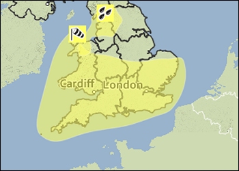 The strongest winds are likely between 5pm-9pm as Storm Barney passes, say forecasters.
“Gusts could reach 60-70mph inland and possibly 80mph along exposed coasts, particularly Wales and through the Bristol Channel,” added a spokesman for the Met Office.
“Gusts of this strength could bring down trees and lead to some damage to weakened structures.”
He added: “A deepening area of low pressure is likely to track east across southern Ireland and then central parts of the UK during Tuesday afternoon and evening, with a swathe of very strong winds potentially developing on the southern flank of the low,” added the spokesman.
“At this stage, the worst of the winds are expected to reach West Wales mid to late afternoon, sweeping rapidly eastwards during the evening. There remains uncertainty in this evolution and particularly the location of the strongest winds.”
Walkers are being advised not to put themselves at risk, keeping away from exposed areas during the strongest winds.
Pictured: Storm waves in Burnham earlier this year. Seafront walkers are being urged not to put themselves at risk during the high winds